After two solid weeks of doing next to nothing, I've finally started going through my pictures. As I get the chance to go through each folder, I'll try to post my favorites in the form of Picasa Albums.
A couple of quick details:
10,047 miles (not including Ct.)
5,025 pictures (including Connecticut, not including cell phone pics)
36 days (with only 4 nights in motels and 8 with friends or family)
2 Oil Changes
1 Windshield (repaired when I got home)
States / Provinces that I drove through, in order (with returns):
MA, VT, QC, ON, MI, WI, MN, ND, MT, ID, WA, OR, (ID, MT, ID), WY, (ID, MT, WY), SD, IA, IL, IN, OH, PA, NJ, NY, CT, (MA)
The only ones I did not spend a night: WI and OH; IA is the only one I feel I did not truly explore much at all (despite sleeping in the state).
Still have some pics to get off my phone. (Especially some food pics.)
Well, here's the first round of new pictures: Teddy Roosevelt NP, South Unit pics
Monday, August 25, 2008
Monday, August 11, 2008
Home again, home again
Well, I've made it back to Massachusetts. Let the dogs out. (Yup. That was me.) Got started on cleaning out the Element. Realized that I'm not planning on being in a different state any time in the near future, so I sat my butt down and probably won't move for a week. I might watch a DVD or play a video game, but, mostly, I'm going to relish not needing to be on the go.
At some pointin the next few days when I feel like it, I'll publish some flikr slide shows of more of my pics. I have about 4k to go through, cull, develop, etc, so it may take some time. I also want to post highlights and what I would have done differently. That'll happen 'round about the same time as the slide shows.
Maybe, just maybe, I might head up to the Whites before school starts. If I do, I'll leave some breadcrumbs here.
At some point
Maybe, just maybe, I might head up to the Whites before school starts. If I do, I'll leave some breadcrumbs here.
Sunday, August 10, 2008
Made it to Pittsburgh
Got shanghaied by a little silly bundle of energy.

Went to Phipps.

Met some friends.

Had a party.
Heading out to NJ, then home.

Went to Phipps.

Met some friends.

Had a party.

Heading out to NJ, then home.
Thursday, August 7, 2008
haven't posted in a while...
Figured I otta check in.
went to cubs astros game. toured fermi labs. went to indiana dunes
nat. lakeshore. currently waiting in line for millenium force at
cedar point. will head into pittsburgh tonight so that my friend and
i can take his daughter to kennywood for her fifth. will post pics
and food when i have good net.
sadly, only a couple of days left on this trip. :_(
Tuesday, August 5, 2008
Quick Post
So, yesterday was a marathon drive. I left SD's Badlands by about 7:00am (MDT - 8:00am CDT); I got into Davenport by 9:30pm CDT. That was a looooonnnnnnnggggg daaaaaayyyy. I decided to not really explore Iowa to keep on schedule. (I have a ticket for the Cubs / Astros game today. Hope it clears up.) The only "attraction" I stopped for was the Corn Palace. I feel somewhat gypped. It's made of bricks and covered with corn. False Advertising.
I will say that Iowa is much hillier than expected. I was planning on some stretches where I could (at the advice of a friend) tie the steering wheel to my belt and take a nap. A good 10-mile snooze would have been a nice break from the hours-long 3-mile straight stretches mixed in with gentle curves. Sadly, the roads curve just a bit too much for a driving nap. Oh well. It probably would have frightened anyone driving past me.
Off to Fermi Labs, the game, and Chicago.
Saturday, August 2, 2008
Back in Wyoming... and damn!
So I left Bozeman after seeing a bit of the Sweet Pea Festival. Very cool.
I saw the Battle of Little Bighorn National Battlefield. Amazing. Being able to walk the field and see the markers of fallen soldiers and braves brings the story home in a way that no book ever can. The monument erected in the 1990's is very poignant.
...and now for the damn! part: Not only is this the opening week of the Sturgis SD Bike Ralley (So traffic will suck), but John McCain will be in town (so traffic will double suck).
Oh well. I guess I'd been having too much good luck on this trip.
[ETA]: I went right past Sturgis. I just didn't want to deal with the mess. The overflow of bikers was spectacular. Everywhere in the area had just droves of bikers. (Is that the right term? Club? Pack? Troop? Sounds too much like the Boy Scouts...)
Friday, August 1, 2008
Bison and Wolves and Bears, oh my!
Oh, and the smell. That's one thing about Yellowstone Nation Park that no one ever told me about. I should have figured, (you know, being a chemist and all...), but all of those hydrothermal features release Hydrogen Sulfide. Its intensity ranges from barely noticeable to gag-inducing. On the other hand, the smell is just something you have to deal with, if you want to see some of the coolest parts of YNP.
As you'd imagine, there's a lot of wildlife around. And, when there's people and wildlife, there's people taking pictures of wildlife. "Bear Jams" are the traffic issue in the area. (And the delays aren't always due to bears. If it's fuzzy and along the road, people will stop and take its picture.) Now, I have nothing against this concept, except DON'T STOP YOUR CAR IN THE MIDDLE OF THE ROAD, PEOPLE! Whew, I've been wanting to say that for three days now. Anyway, my list includes: bison (again, they're really not pretty creatures), mule deer, elk, pronghorn (well, in the Tetons), moose (again, GTNP), black bears (which is a species, not a true color) coyotes, and wolves. No Grizzlies, and no longhorn sheep.
YNP is really more of a bunch of parks rolled into one. The southern half, plus Mammoth (north-western section) comprise the large bulk of the active thermal features. (Although there are others out in the back country of the north-eastern, I see on my topo map. Each quadrant of the park has its own feel. There's the Yellowstone Lake (SE), Old Faithful (SW), Mammoth (NW) and Tower / Roosevelt (NE). Even staying a week in each quarter wouldn't give you the whole story. My three day trip was almost too hectic. I pulled into the campsite each night just drained from trying to see all that I could see. And I didn't even go into the backcountry. (Something I had hoped I'd have time for.) Oh well, that just means I have to come back. Dang. ;-)
Anyway, I now have a good connection. (I'm in Bozeman, MT; I'll be meeting up with an old friend of dad's family.) Some quick pics without too much discussion, I'm afraid. Hydrothermal region near Yellowstone Lake
 Another feature from the same region.
 Artist's Paint Pots, near Old Faithful
 The Lower Falls of the Yellowstone River (in the middle of the Park)
 Canary Springs, Mammoth
 Wolf in Tower / Roosevelt. (Told you it'd be blurry.)
As you'd imagine, there's a lot of wildlife around. And, when there's people and wildlife, there's people taking pictures of wildlife. "Bear Jams" are the traffic issue in the area. (And the delays aren't always due to bears. If it's fuzzy and along the road, people will stop and take its picture.)
 Now, I have nothing against this concept, except DON'T STOP YOUR CAR IN THE MIDDLE OF THE ROAD, PEOPLE! Whew, I've been wanting to say that for three days now. Anyway, my list includes: bison (again, they're really not pretty creatures), mule deer, elk, pronghorn (well, in the Tetons), moose (again, GTNP), black bears (which is a species, not a true color) coyotes, and wolves. No Grizzlies, and no longhorn sheep.
YNP is really more of a bunch of parks rolled into one. The southern half, plus Mammoth (north-western section) comprise the large bulk of the active thermal features. (Although there are others out in the back country of the north-eastern, I see on my topo map. Each quadrant of the park has its own feel. There's the Yellowstone Lake (SE), Old Faithful (SW), Mammoth (NW) and Tower / Roosevelt (NE). Even staying a week in each quarter wouldn't give you the whole story. My three day trip was almost too hectic. I pulled into the campsite each night just drained from trying to see all that I could see. And I didn't even go into the backcountry. (Something I had hoped I'd have time for.) Oh well, that just means I have to come back. Dang. ;-)
Anyway, I now have a good connection. (I'm in Bozeman, MT; I'll be meeting up with an old friend of dad's family.) Some quick pics without too much discussion, I'm afraid.
 Hydrothermal region near Yellowstone Lake
 Another feature from the same region.
 Artist's Paint Pots, near Old Faithful
 The Lower Falls of the Yellowstone River (in the middle of the Park)
 Canary Springs, Mammoth
 Wolf in Tower / Roosevelt. (Told you it'd be blurry.)
Thursday, July 31, 2008
500mm lens + doubler + 1.6x for digital =
still not enough magnification.
Wolves! At least 5 of them! Unforetunately, they were on the other
side of a valley, which was about a mile away. I had pulled over to
see what all the people with heavy-duty scopes were looking at. A few
of them do this on a regular basis. They were wonderfully nice; not
only did they let me peek through the scope to set up my shot, but a
family with two small children came by, and the pros took the time to
let all four look through. (And, as you can imagine, it was some work
to get the kids to see the right thing, but the pros took the time,
even while trying to keep up with the pack's movement.)
So, I have some black fuzzy sillouettes in some out of focus pictures.
But I saw wolves!
Yellowstone is on fire!
A comparatively small part of the park is burning in the southern
area. Luckily, I did that area two days ago. I'm now up north. Will
post pictures when I have real net.
area. Luckily, I did that area two days ago. I'm now up north. Will
post pictures when I have real net.
Monday, July 28, 2008
A couple of miscalculations later...
I had decided to get into the Western side to see more of the area than most folks do. (I have a hunch a large percentage of people drive into the park, through it, camp once or twice, maybe take a float trip, and that's about it.)  So I went back into Idaho and stopped into a bike / outdoor shop to get some advice on picture locations. One guy suggested I go up "The Devil's Staircase"; he claimed it should take me about one and half hours (Ha!) and that there would be alot of great scenery along the way. So, up I went, at about 8:30am yesterday. When I got to the top (in nowhere near 1 & 1/2 hrs), the view was good, but I thought I'd get a little better view a bit further up the trail. Hmmm... the views kept getting better, and I wasn't panting too hard from the altitude. (In fact, I may be becoming acclimated, which would be cool. That means more red blood cells and being in better shape when I return to lower altitudes.)
 I was actually hiking along a hanging valley, in and out of snowpack. It was so cool, I kept going and pushing off when I'd stop for lunch. Just after I ate, a couple of teachers from Calgary met up with me. (read: were hiking a much faster pace than me.) We talked for a bit. It turns out I was better equipped for the day - I had a map. So we talked about routes and whether to turn back or keep going for a little bit or go all the way around the canyon. Looking at the map, all the way around didn't look too bad, and not that much further. (Important note, I didn't have my best map of the area on me.)
 Well, they went on ahead of me, while I took a side trip to the edge of the hanging valley to get a picture of the three Tetons (and definitely one that's not got tripod-marks). I decided that I wanted to get up to the Mount Meek Pass. Some other hikers had told me that I'd find a hidden lake that was "worth it". I may have been, but, unfortunately, I never did find the lake. Partly because I wasn't quite as far along as I thought. So by the time I made it to the area where the lakes are, I was only thinking about getting back to the car. In no small part because I could see that my shadow was getting longer.
(By the way, another of my misconceptions is how easily I burn, and how easy it is to not notice this when there's a nice cool breeze. Oh, and how much reflected sun can burn, too. I am now a very unbecoming shade of red on my forearms, face, and neck. Ouch.)
 One more misconception was that stream crossing would be relatively easy. Most were. Some even had either bridges, fallen trees, or intentionally placed rocks. But, if it's been a really hot couple of days, the snow will be melting faster than the rock-placer expect. This makes crossing streams a decision. In a couple of places, the decision was to cross barefoot, and thus have warm, dry boots after the crossing, or hike in wet, cold boots. Did I mention that these streams are the result of melting snow / ice? That means they're somewhere around 33-34 degrees. Crossings like these were not fun.
Anyway, I did eventually make it out to post about my adventures. (Obviously) I made it back to the car at 8:30. 12 damn hours of solid hiking. Looking at the map, yesterday was about 18-19 miles. Checking altitudes: Trailhead, let's say 6976; Mount Meek Pass, 9726. Difference: 2750.
Just a few minor miscalculations...
 So I went back into Idaho and stopped into a bike / outdoor shop to get some advice on picture locations. One guy suggested I go up "The Devil's Staircase"; he claimed it should take me about one and half hours (Ha!) and that there would be alot of great scenery along the way. So, up I went, at about 8:30am yesterday. When I got to the top (in nowhere near 1 & 1/2 hrs), the view was good, but I thought I'd get a little better view a bit further up the trail. Hmmm... the views kept getting better, and I wasn't panting too hard from the altitude. (In fact, I may be becoming acclimated, which would be cool. That means more red blood cells and being in better shape when I return to lower altitudes.)
 I was actually hiking along a hanging valley, in and out of snowpack. It was so cool, I kept going and pushing off when I'd stop for lunch. Just after I ate, a couple of teachers from Calgary met up with me. (read: were hiking a much faster pace than me.) We talked for a bit. It turns out I was better equipped for the day - I had a map. So we talked about routes and whether to turn back or keep going for a little bit or go all the way around the canyon. Looking at the map, all the way around didn't look too bad, and not that much further. (Important note, I didn't have my best map of the area on me.)
 Well, they went on ahead of me, while I took a side trip to the edge of the hanging valley to get a picture of the three Tetons (and definitely one that's not got tripod-marks). I decided that I wanted to get up to the Mount Meek Pass. Some other hikers had told me that I'd find a hidden lake that was "worth it". I may have been, but, unfortunately, I never did find the lake. Partly because I wasn't quite as far along as I thought. So by the time I made it to the area where the lakes are, I was only thinking about getting back to the car. In no small part because I could see that my shadow was getting longer.
(By the way, another of my misconceptions is how easily I burn, and how easy it is to not notice this when there's a nice cool breeze. Oh, and how much reflected sun can burn, too. I am now a very unbecoming shade of red on my forearms, face, and neck. Ouch.)
 One more misconception was that stream crossing would be relatively easy. Most were. Some even had either bridges, fallen trees, or intentionally placed rocks. But, if it's been a really hot couple of days, the snow will be melting faster than the rock-placer expect. This makes crossing streams a decision. In a couple of places, the decision was to cross barefoot, and thus have warm, dry boots after the crossing, or hike in wet, cold boots. Did I mention that these streams are the result of melting snow / ice? That means they're somewhere around 33-34 degrees. Crossings like these were not fun.
Anyway, I did eventually make it out to post about my adventures. (Obviously) I made it back to the car at 8:30. 12 damn hours of solid hiking. Looking at the map, yesterday was about 18-19 miles. Checking altitudes: Trailhead, let's say 6976; Mount Meek Pass, 9726. Difference: 2750.
Just a few minor miscalculations...

Saturday, July 26, 2008


Friday, July 25, 2008
in re Tourist Traps
So, I've made it to Jackson, Wy (sometimes called Jackson's Hole). It's the kind of place that's gotta be great to visit, if you have money. One of these days, I've got to figure out some way of getting some of that... It has to be shocking for anyone who grew up in this area just how fast it's become a tourist trap; the town is just barely more than a century old. The town square, which was known for having cattle and elk even into the 20's (and maybe 30's) is now surrounded by some rather pricey shops. The Teton Village is pushing the term "village".
It's not a bad town by any stretch. And I don't mean to imply that all that glitters is evil. It's just a bit of culture shock coming from Montana, where someone had put up signs stating their opinions of a housing development ("high density housing", it was called) that, had it been in Mass, would have been pretty well spread out.
Anyway, the view from the Teton Pass looking into the "Hole" (valley) was nice this am. I'll be heading into the hills for the next couple of days. I'll try to come out to pop my head up and post once or twice before heading up to Yellowstone.
P.S. I now have bear spray. I've been told that, if the spray isn't enough to deter the bear, the last resort is to cover yourself and hope the bear doesn't like the taste. I hope that part's a joke.
It's not a bad town by any stretch. And I don't mean to imply that all that glitters is evil. It's just a bit of culture shock coming from Montana, where someone had put up signs stating their opinions of a housing development ("high density housing", it was called) that, had it been in Mass, would have been pretty well spread out.
Anyway, the view from the Teton Pass looking into the "Hole" (valley) was nice this am.
 I'll be heading into the hills for the next couple of days. I'll try to come out to pop my head up and post once or twice before heading up to Yellowstone.
P.S. I now have bear spray. I've been told that, if the spray isn't enough to deter the bear, the last resort is to cover yourself and hope the bear doesn't like the taste. I hope that part's a joke.
A Real Live, er..., not, Ghost Town
So, I just decided to take a detour into Bannack, MT. Possibly the coolest detour I've taken yet. On the MT state maps, they label ghost towns, and I saw that this one was labeled as a National Historical Site, so I took the trip.
 Although it was a mining town (and, at least for a while, the capital of the Montana Territory), it is only recently a ghost town. The last residents left in the early 1970's. (Although, there were only a few of them left by that time.) One of the neat things about the site is that it's been taken over by as a State Park, but part of the stipulations in the deeding was that it retain its original ghost town feel and to "not become touristy like Virginia City". (That's as close of a quote as I can remember.)

Since some of the buildings have been lived in for a century or so, you can see how they were updated over time. And, now that they're falling apart, you can really see the different layers of housing. Some were very well done, at one point. The curving stairwell in the hotel was obviously done by someone who knew their stuff. Solid mahogany railing and ballisters, curved plaster wall around the staircase, etc. I heard a couple of guys talking about how there might be interest in restoring the building. Could be neat, if done right. But it will certainly be a of work.
Took me a while, but I did find one ghost in the town. A bartender, as it so happens.  Ugly lookin' cur. I wouldn't trust what he's pouring.
 Although it was a mining town (and, at least for a while, the capital of the Montana Territory), it is only recently a ghost town. The last residents left in the early 1970's. (Although, there were only a few of them left by that time.) One of the neat things about the site is that it's been taken over by as a State Park, but part of the stipulations in the deeding was that it retain its original ghost town feel and to "not become touristy like Virginia City". (That's as close of a quote as I can remember.)
Since some of the buildings have been lived in for a century or so, you can see how they were updated over time. And, now that they're falling apart, you can really see the different layers of housing. Some were very well done, at one point. The curving stairwell in the hotel was obviously done by someone who knew their stuff. Solid mahogany railing and ballisters, curved plaster wall around the staircase, etc. I heard a couple of guys talking about how there might be interest in restoring the building. Could be neat, if done right. But it will certainly be a
Took me a while, but I did find one ghost in the town. A bartender, as it so happens.
 Ugly lookin' cur. I wouldn't trust what he's pouring.
A Couple of Detours
In my original plans, on Wednesday, I was going to leave Hell's Canyon area for Craters of the Moon National Monument. After I'd heard repeatedly that it's only kinda worth it to head to, and that Rt 12 through Idaho is a better bet, that's the way I went. Rt 12 is an area rich with history. It runs along (and mostly underneath) an ancient indian trail known as the Lolo trail. This trail was used as a means of trade and communication by the native tribes, as part of the route Lewis and Clark took during their navigations, and as the primary route out of Imnaha canyons by the Joseph Band of the Nez Pierce, as they were trying to escape "relocation" by the US government. ("Nez Pierce" is really pronounced more like Ne-mi-po. Maybe someone can comment in why the two names.)
Due to the time of day, and the winding, mountainous aspects of the road, I don't have too many pictures along Rt 12. The detour was certainly worth it, though. Especially because I would not have taken the next detour I'll talk about. If nothing else, the Lolo Steakhouse would have been worth the detour. (Gotta get a new Food Files going before it gets too long.)
One picture from rt 12 shortly before camping out for the night.

Wednesday, July 23, 2008
Time to change plans again...
I've been told by multiple people that I really need to go North into Idaho to take rt 12 into Montana. I've been told that this may be the single prettiest drive in the country. We'll see. So, I am going to head north from Enterprise, Or into Id, from there into Montana, and then south again back into Idaho - a lot of driving. I have no idea where I will stop for the night. Probably another rest stop night. Anyway, this should put me getting into Jackson, Wy sometime tomorrow.

Anyway, now that that's out of the way... I've been to one amazing part of Hell's Canyon area. The drive out to Hat Point is both difficult and oh-so-worth-it. Combine the best and worst parts of that dirt road in UP Mi and the GttSR in GNP. 24 unpaved miles of switch-backs, no shoulders, and amazing scenery. But it gets you out to the Hat Point Look Out, which looks into Hells Canyon. (As close to the canyon as I'm going to get on this trip, alas.) Hells Canyon is actually deeper than the Grand Canyon. There's a fire-tower at the top of Hat Point, in case the mountain's not high enough for you. But, since the point is at 7000 feet high, bring oxygen, or plan on taking longer than you might otherwise...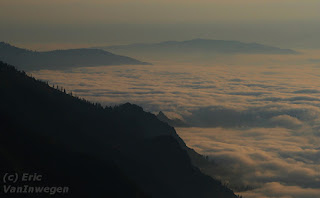 (Yup, once again I'm blaming the altitude, not my lack of excercise.) In the morning, I got the chance to drive above the clouds. Now, I've driven through them and hiked above them, but never driven above them. So cool.
Gotta get back on the road before I get to complacent in this coffee shop / brew pub / restaurant in Joseph, Or. (If I lived near by, I'd never leave!)

Anyway, now that that's out of the way... I've been to one amazing part of Hell's Canyon area. The drive out to Hat Point is both difficult and oh-so-worth-it. Combine the best and worst parts of that dirt road in UP Mi and the GttSR in GNP. 24 unpaved miles of switch-backs, no shoulders, and amazing scenery. But it gets you out to the Hat Point Look Out, which looks into Hells Canyon. (As close to the canyon as I'm going to get on this trip, alas.) Hells Canyon is actually deeper than the Grand Canyon. There's a fire-tower at the top of Hat Point, in case the mountain's not high enough for you. But, since the point is at 7000 feet high, bring oxygen, or plan on taking longer than you might otherwise...
 (Yup, once again I'm blaming the altitude, not my lack of excercise.) In the morning, I got the chance to drive above the clouds. Now, I've driven through them and hiked above them, but never driven above them. So cool.
Gotta get back on the road before I get to complacent in this coffee shop / brew pub / restaurant in Joseph, Or. (If I lived near by, I'd never leave!)
Tuesday, July 22, 2008
Three quick posts below
Now that I'm on the road again, I realized that I've been remiss in posting. I've been so busy having fun that I've forgotten to post about it here.
Yesterday was my western-most day of the trip. I spent a little bit of time along the Olympic coast.
 I have just hit the Oregon / Washington border. The drive through the Cascades was incredible. Once you hit the eastern side, the whole Topological-influence-on-the-ecosystems was amazingly obvious. On the western side, where all of the rain falls, the mountains are covered with thick, lush forests. About ten miles down the road from the pass in the mountains, the forests abruptly turn in to prairie hills. The change is so fast that it just really hits you.
Anyway, enjoy the (late) posts; time to get myself in gear to make Hell's Canyon tonight.
Yesterday was my western-most day of the trip. I spent a little bit of time along the Olympic coast.
 I have just hit the Oregon / Washington border. The drive through the Cascades was incredible. Once you hit the eastern side, the whole Topological-influence-on-the-ecosystems was amazingly obvious. On the western side, where all of the rain falls, the mountains are covered with thick, lush forests. About ten miles down the road from the pass in the mountains, the forests abruptly turn in to prairie hills. The change is so fast that it just really hits you.
 Anyway, enjoy the (late) posts; time to get myself in gear to make Hell's Canyon tonight.
Holy-Freakin'-Huge-Trees, Flying-Nocturnal-Echo-Locating-Mammal-Man!
I was almost going to skip Olympia National Park, and that would have been a crime. Looking at my schedule, I realized that I need to re-prioritize and spend an extra day in Washington exploring the Olympic Peninsula. Yet another place, that, you guessed it, deserves its own trip, and not just a quick run-through. Seattle is known for being a rainy-cloudy city, but it has nothing on the forests of the peninsula. Between rain and snow and etc, they get (on average) 140 inches of precipitation. (I forgot that snow gets "rescaled" when you calculate precipitation; it's something like a foot to an inch, or so.) The ridiculous amount of rain gives the trees in ONP a chance to grow incredibly large. They have a neat display in one of the ranger stations of trees grown in ONP compared to tress of the same species grown elsewhere. The difference is staggering! In the ONP, the trees can grown almost ten times as much in one year. It's hard to get the impact of the size of the trees across in pictures, you lose your sense of scale without a reference mark. So, since I had no one to better looking who'd volunteer, I had to model in my shots. Since I also had to work the camera, this meant that I would set up the tripod, set the camera to the timer, push the button, and run as fast as I could to get into position. Sounds easy, right?
This fella was well over two hundred feet tall / long.

This fella was well over two hundred feet tall / long.
Seattle
After our driving and hiking, we explored Seattle's famous market downtown. Like a lot of these "farmers markets", it's become kinda touristy more so than a true farmers market. But there were still plenty of stalls selling fresh fish and produce, as well as some amazing places to get local cuisine. (The next food files will be a happier one.)


After exploring, I used the time to get the car an oil change (it's been more than 4k since I left Mass) and a haircut (think Egon Spengler from Ghostbusters, only shaggier), while my buddy and his girlfriend played a softball game. Afterwards, we toured a bit more of Seattle and went to the Space Needle for dinner. TSP restaurant has a reputation with the locals as being a tourist trap. It kinda is, but it's better than most. Although it was certainly expensive, it was (mostly) worth it. The atmosphere was entertaining; however the spin was a bit jerky at times. Not so much that you'd knock over a glass, but just enough to make you notice it. Overall, I'd say that, if you have the money to spare, go for it; if you're on a tight budget, you could skip it without missing too much.


After exploring, I used the time to get the car an oil change (it's been more than 4k since I left Mass) and a haircut (think Egon Spengler from Ghostbusters, only shaggier), while my buddy and his girlfriend played a softball game. Afterwards, we toured a bit more of Seattle and went to the Space Needle for dinner. TSP restaurant has a reputation with the locals as being a tourist trap. It kinda is, but it's better than most. Although it was certainly expensive, it was (mostly) worth it. The atmosphere was entertaining; however the spin was a bit jerky at times. Not so much that you'd knock over a glass, but just enough to make you notice it. Overall, I'd say that, if you have the money to spare, go for it; if you're on a tight budget, you could skip it without missing too much.
The Lonely Mountain
After a long haul of a drive from GNP, the next day, my buddy, his girlfriend and her kid and I decided to go to Mt Rainier. We were only able to walk about a bit, no backpacking or anything. It's another amazing place, worthy of a trip in and of itself. I call it the "Lonely Mountain" because it doesn't really have many neighbors, just parts of itself. It's a volcanic mountain (active, sort of), so it just grew were the hot spot is. On even kinda clear days, you can see the white glacier-covered top "floating" in the air from Seattle.
The park is set up so that you could climb to the top in two days. I'm not sure I'd be able to do that, but you never know. (Maybe one day I'll start on the High-Points in each state, so I'll have to.) Of course I took a bunch of pics, so here's one. (It's from the ride back home.)
The park is set up so that you could climb to the top in two days. I'm not sure I'd be able to do that, but you never know. (Maybe one day I'll start on the High-Points in each state, so I'll have to.) Of course I took a bunch of pics, so here's one. (It's from the ride back home.)

Friday, July 18, 2008
Fast Ponderings on GNP
So, now that I am on the road again, I figure it's time for a wrap-up on GNP. (That's Glacier National Park; try to keep up with the acronyms.)
GNP was yet another park that was worthy of its own trip. If I had another month, I wouldn't have seen it all. If I could spend a full year at GNP, it'd be different every day. It' very much the kind of place I could fall in love with (and, indeed, have). There are a couple of things that I should point out to anyone thinking of visiting the park. #1, if you don't like mountain roads, try visiting the National Grassland between the TRNP units. The Going to the Sun Road connects the two sides. The East-to-West route is less worrisome. You tend to be on the inside of the road most all of the way. West-to-East is a bit ... more knuckle-whitening. I now have fingernail marks in my steering wheel.
In the more people-frequented areas, some of the wildlife gets disturbingly familiar with humans. Up near Logan's Pass, at both the Hidden Lake overlook and the viewing area just to the West of the pass, mountain goats get so comfortable around people that I could have petted them, if I choose to. Needless to say, I now have some "Nature" shots of mountain goat kids. It's almost cheating.
Avalanche Lake is another popular destination. The trail is right next to one of the larger camping areas and is very well maintained. That is, it's well maintained right up to the point where it claims to stop. They even have a sign proclaiming that this is the "end of the trail, don't go any further." So, of course, there is a trail, and I did go further. But not too much. The US government may claim to possess the GNP, but it's really the grizzlies' property. The area just beyond the "end of trail" sign was decidedly grizzly territory. Brush about 6 feet tall, cascading streams, fresh fish supplies, plenty of places to make dens, etc. So, of course, I had to venture a little bit in, right? Just long enough to snap a couple of pictures (but I didn't even stay long enough to set up my tripod). Let's think about all of the things that were wrong with this idea: Lone hiker, hours getting long, no bear-spray, etc, etc. I made sure that I was one noisy hiker, and only went about 2 minutes into the end of the valley. For the next visit, I'm bringing at least one hiking partner, and at least one can of spray, and I am definitely going to return and head a little further in. Also, I did no backpacking. The Ptarmigan Path has my name on it, I think.
Time to get back in the car and get moving, I think. Sorry, no pics. They're still on the camera.
The Food Files 2: The Food Strikes Back
...or... a Dying Diner, two Disappointing Dinners, and Campfire Cuisine.
(Meant to post this last night, but was too exhausted after a good 10-mile day. More on that in the next post. I drafted this Wednesday night while I digested my campfire meal.)
The Dying Diner:
On my way out of Minneapolis & St. Paul, I was aiming for the west side of Fargo, so I was pushing pretty hard. There was a lot of driving to do between the Twin Cities and Teddy Roosevelt National Park. Saturday afternoon rolled around, and it was time for me to get a-movin'. Once I'm a-movin', I don't like a-stoppin'. I pulled off the highway only as needed for gas, liquids (either taking on or getting rid of), and food. One thing I noticed about western Minnesota (and, for that matter, Wisconsin) is that when the signs along the highway say that there is (for example) food or gas at a particular exit, they don't mean right at the exit. Could be five, ten, who-knows how many miles down the road. And, to make matters even more entertaining, they don't both putting up signs telling you how far down the road your destination is. They just leave little bread-crumbs of signs pointing in the direction. It's sort of a little game they play in these states. (Let's see how many miles out of the way we can get the tourists to drive before they are either lost or fed up! Wheeeee!) After my third (or was it four th?) time giving up and turning around ten miles down some country road, I decided that I just had to have faith and follow the signs. I finally found Ruby's City Restaurant; it was some little diner that used to be on a main road, but is off the interstate by about ten miles. Another casualty of the Eisenhower Interstate System. (Ike's system is fine for travel, but it sure has put a bite on anything that's no longer right on the main road.) Simple, but well prepared food was at my table in short order. (Get it? Short order? That's a joke...) I was too busy taking pictures of the place (and too hungry to take pictures of the food), but you've seen what a BLT looks like.
Disappointment #1
Seduced by the sultry sound of sweet-spicy sauce, I was instead abandoned by blubbery, rubbery bison "barbecue". N ow, I like buffalo. (The price, not so much). So, when I saw the sign for barbecue in the town of Medora (where the South Unit of TRNP is), I felt myself drawn in by the idea that in an old cattle town, somebody's surely got to know how to do Q. And when I saw buffalo brisket on the menu, how could I resist? I should have tried harder. A combination of not being cooked long enough to render connective tissue and being poorly sliced (with the long, chewy grain, instead of across it) left a sandwich that had more in common with Gumby than good brisket. Then, for the next kick in the teeth, as I was leaving town, I finally saw a sign for cowboy fondue. Meat cooked in hot oil, on a pitch-fork. I have heard good things about this, but unfortunately, found the location too late. Alas, for the advertising industry has once again done me wrong!
Disappointment #2
Weary from long hauls, both in the car and dragging my butt up snowy inclines at high altitudes, I found the best looking (or, grammatically, I should say 'better looking') restaurant in St. Mary. Looks good, in a hotel, got a good singer in the lounge; I am all ready for good culinary things to happen. Order a buffalo steak "cowboy-style". While I'm waiting for this to come, I am given some bread and a good herby spread to enjoy along with my beverage. ("Moose Drool" it was called; and it was certainly good enough for me.) When the steak finally arrives, I was so famished that I tore into it, barely tasting what was there. The steak was actually cooked medium-rare (how I usually order, but seldom get). Once I was half-way through the steak, it began to dawn on me that my new water glass was empty. Curious. I decided to taste my meal for perhaps the first time, and could hardly believe just how damn salty the thing was. Unbelievable. The steak, the sauce, the potatoes, each one saltier than the next. I hate sending food back; if I hadn't finished half of the steak, I would have. So, with plenty of water, I finished another disappointing meal.
Campfire Cuisine, or "Bragging"
Finally, we get to something good. After spending way too much for a burger, fries, and a soda at a park lodge, I decided that I would cook my own meal tonight. I've been lugging all of this stuff around and have only made coffee and cereal. (Important, but nothing to brag about.) So tonight, planned time to cook over an open fire. On the menu were herbed, spiced potatoes (braised in the secret ingredient), steamed carrots and red pepper, and a spiced, herbed meat patty. (Ok, that was supposed to be a hamburger, but it never browned, just braised in its own juices, which is fine by me.) Once I had all dishes cooking in their own little foil pouches, I had a sudden inspiration! I had all I needed for a Welsh Rarebit sauce! (For those who don't know, Welsh Rarebit is a sauce made from good cheddar
 cheese, a bit of mustard and some of the secret ingredient.) That menu again was braised, herbed, spiced potatoes, steamed vegetables, braised, and spiced, herbed meat patty with Welsh Rarebit Sauce, cooked over, and eaten by, a campfire, and washed down with some more secret ingredient.
Life does not get any better. Or at least it didn't until dessert.

The first one was perfect, the second one was better.
I am one happy, stuffed, fat bastard.
(Meant to post this last night, but was too exhausted after a good 10-mile day. More on that in the next post. I drafted this Wednesday night while I digested my campfire meal.)
The Dying Diner:
On my way out of Minneapolis & St. Paul, I was aiming for the west side of Fargo, so I was pushing pretty hard. There was a lot of driving to do between the Twin Cities and Teddy Roosevelt National Park. Saturday afternoon rolled around, and it was time for me to get a-movin'. Once I'm a-movin', I don't like a-stoppin'. I pulled off the highway only as needed for gas, liquids (either taking on or getting rid of), and food. One thing I noticed about western Minnesota (and, for that matter, Wisconsin) is that when the signs along the highway say that there is (for example) food or gas at a particular exit, they don't mean right at the exit. Could be five, ten, who-knows how many miles down the road. And, to make matters even more entertaining, they don't both putting up signs telling you how far down the road your destination is. They just leave little bread-crumbs of signs pointing in the direction. It's sort of a little game they play in these states. (Let's see how many miles out of the way we can get the tourists to drive before they are either lost or fed up! Wheeeee!) After my third (or was it four
 th?) time giving up and turning around ten miles down some country road, I decided that I just had to have faith and follow the signs. I finally found Ruby's City Restaurant; it was some little diner that used to be on a main road, but is off the interstate by about ten miles. Another casualty of the Eisenhower Interstate System. (Ike's system is fine for travel, but it sure has put a bite on anything that's no longer right on the main road.) Simple, but well prepared food was at my table in short order. (Get it? Short order? That's a joke...) I was too busy taking pictures of the place (and too hungry to take pictures of the food), but you've seen what a BLT looks like.
Disappointment #1
Seduced by the sultry sound of sweet-spicy sauce, I was instead abandoned by blubbery, rubbery bison "barbecue". N
 ow, I like buffalo. (The price, not so much). So, when I saw the sign for barbecue in the town of Medora (where the South Unit of TRNP is), I felt myself drawn in by the idea that in an old cattle town, somebody's surely got to know how to do Q. And when I saw buffalo brisket on the menu, how could I resist? I should have tried harder. A combination of not being cooked long enough to render connective tissue and being poorly sliced (with the long, chewy grain, instead of across it) left a sandwich that had more in common with Gumby than good brisket. Then, for the next kick in the teeth, as I was leaving town, I finally saw a sign for cowboy fondue. Meat cooked in hot oil, on a pitch-fork. I have heard good things about this, but unfortunately, found the location too late. Alas, for the advertising industry has once again done me wrong!
Disappointment #2
Weary from long hauls, both in the car and dragging my butt up snowy inclines at high altitudes, I found the best looking (or, grammatically, I should say 'better looking') restaurant in St. Mary. Looks good, in a hotel, got a good singer in the lounge; I am all ready for good culinary things to happen. Order a buffalo steak "cowboy-style". While I'm waiting for this to come, I am given some bread and a good herby spread to enjoy along with my beverage. ("Moose Drool" it was called; and it was certainly good enough for me.) When the steak finally arrives, I was so famished that I tore into it, barely tasting what was there. The steak was actually cooked medium-rare (how I usually order, but seldom get). Once I was half-way through the steak, it began to dawn on me that my new water glass was empty. Curious. I decided to taste my meal for perhaps the first time, and could hardly believe just how damn salty the thing was. Unbelievable. The steak, the sauce, the potatoes, each one saltier than the next. I hate sending food back; if I hadn't finished half of the steak, I would have. So, with plenty of water, I finished another disappointing meal.
Campfire Cuisine, or "Bragging"
Finally, we get to something good. After spending way too much for a burger, fries, and a soda at a park lodge, I decided that I would cook my own meal tonight. I've been lugging all of this stuff
 around and have only made coffee and cereal. (Important, but nothing to brag about.) So tonight, planned time to cook over an open fire. On the menu were herbed, spiced potatoes (braised in the secret ingredient), steamed carrots and red pepper, and a spiced, herbed meat patty. (Ok, that was supposed to be a hamburger, but it never browned, just braised in its own juices, which is fine by me.) Once I had all dishes cooking in their own little foil pouches, I had a sudden inspiration! I had all I needed for a Welsh Rarebit sauce! (For those who don't know, Welsh Rarebit is a sauce made from good cheddar
 cheese, a bit of mustard and some of the secret ingredient.) That menu again was braised, herbed, spiced potatoes, steamed vegetables, braised, and spiced, herbed meat patty with Welsh Rarebit Sauce, cooked over, and eaten by, a campfire, and washed down with some more secret ingredient.
 Life does not get any better. Or at least it didn't until dessert.

The first one was perfect, the second one was better.
I am one happy, stuffed, fat bastard.
Wednesday, July 16, 2008
Long overdue musings
I've finally made it all the way across the Going to the Sun Road that runs through the middle of Glacier National Park. It's kind of like the Kancamangas Highway back in the Whites, only more so. I am in West Glacier, which is surprisingly less expensive of a place than East Glacier. I'll be heading back along the GttSR in a little while. On one hand, I feel like I've been doing some major exploring and picture-taking. I take so many picture opportunities along the way that some of them have to be good. But, saying I've explored GNP after driving along the GttSR is like saying you've explored the Whites by driving the Kangamangas. I might try to take one of the hikes suggested to me at the visitor center today. (And will once again blame the altitude on my huffing and puffing.)
I'm hiding and updating while the sun's too bright / high. There is WiFi here, but not free, so I'm sitting in the Element typing up all of the posts I've been thinking about over the last couple of days.
So here you are: The great insights into some of what I've been thinking as I travel.
Title: The gentle tap-tap-tap of...
the friggin' bugs hitting my windshield!
My car and windshield are covered in their remains. I am now an expert in the sound to splatter ratio. From the gentle tip of the little ones to the SPLAT of the big streak-leaving ones. I have no idea what kind each is, other than to mention the various resistances to windshield-washers their corporeal remains leave. Oh well, at least they're not birds.
Update: Damn! That one was a bird! I got lucky that it didn't hit my windshield. I didn't even have time to react / slow down / swerve. I just saw something large flying across my view, then THUD! and a shower of feathers. A little while later, when I stopped to take a picture of something along the road. I noticed that the dead bird was stuck inside my grill. Ick. I felt bad, but, hey, it was either him or me, right? (Why am I reminded of South Park? He's coming right at me! *blam* ) I did feel so bad that I didn't take a picture of the carnage. It was kinda colorful, in a nasty sort of way...
Title: Montana's a big damn state.
So, I pulled into the info station as soon as I hit the eastern border. The lady inside told me (in such a sure tone) that the best route was to go up to US 2 and over. I saw on e the map that it is along the Lewis and Clark Trail. Ok, I figured, that must mean there's stuff worth seeing. And there was, if the stuff you like seeing is great big expanses of flat. Towards the end, I did pass south of the Sweet Grass Hills, which are kinda neat, but only a little and only for a little while. The entertaining thing (to me) is that, since much of what I drove through was Indian Reservations, there were casinos everywhere! And I don't mean big ones, but little one or two room dealies, often attached to gas stations. I wonder how they came up with that concept. Hey, I wonder if those folks who need gas want to risk their money in a tiny, frightening casino. Yeah, I bet they do. What a great idea! I should have gotten the courage to stick my head in, or even waste a couple of bucks just to see who goes in these places. Maybe I'll do that on the way to Seattle. I'll report back with the scoop, if I see one.
Title: The Caccoon
Ruby (the Element) has ended up being a great way to travel, but somewhat limited as a camper. When I'm ready to turn in for the night, the routine goes: Screens up (one is just this side of falling apart), hop in so I don't let the skeeters in, practice some 4th level yoga moves to get the front seat down while I am in it, arrange the bed, then put up the privacy curtains, while I am lying in bed. Let's talk about the curtains. I forget how much I paid for them; they're the ones Honda sells. Of the four things I bought with Ruby (curtains, sun-roof screen, table legs, and arm rest), so far the arm rest has been the best value (and I had to search to find it - it's not one of their "premier" accessories). The curtains could have been much better designed. They have these little tabs that slide into the tiny gap between the plastic molding and the fabric above the windows. There are a couple of hooks that actually attach to something, but the majority of the support is from these little tabs. This all means that, if I am not careful, it is really easy to bump up against the curtain, and cause one or more of the tabs to slide out. Now, I'm not too worried about someone seeing in. (In the back, the windows are very darkly tinted.) But finding the right spots for these foolish little tabs while lying on my back is a pain in the arm. (They're finicky little things; there's only so many places they'll actually go, and of those places, you gotta find juuust the right one so as to not pull out any of the adjacent ones.) I can't help but think that a couple of snaps or some velcro would have been a much better concept. And there nothing on the bottom of them to keep the curtains from moving, or falling down once you touch them. Again, just a little more work would have made this a much more useful product.
Anyway, once I am in for the night, it's not bad. Although I miss my wonderful bed back in Mass, the platform and mattress are doing alright. I've certainly slept on much worse.
So there you go. Anyone who was interested in knowing what (if anything) is going through my head while I'm driving. It's not just that my mind wanders a little, it's also that there's so much space out here for it to wander. Then again, maybe you didn't really want to know all of the above. Perhaps some things are better left as a mystery.
I'm hiding and updating while the sun's too bright / high. There is WiFi here, but not free, so I'm sitting in the Element typing up all of the posts I've been thinking about over the last couple of days.
So here you are: The great insights into some of what I've been thinking as I travel.
Title: The gentle tap-tap-tap of...
the friggin' bugs hitting my windshield!
My car and windshield are covered in their remains. I am now an expert in the sound to splatter ratio. From the gentle tip of the little ones to the SPLAT of the big streak-leaving ones. I have no idea what kind each is, other than to mention the various resistances to windshield-washers their corporeal remains leave. Oh well, at least they're not birds.
Update: Damn! That one was a bird! I got lucky that it didn't hit my windshield. I didn't even have time to react / slow down / swerve. I just saw something large flying across my view, then THUD! and a shower of feathers. A little while later, when I stopped to take a picture of something along the road. I noticed that the dead bird was stuck inside my grill. Ick. I felt bad, but, hey, it was either him or me, right? (Why am I reminded of South Park? He's coming right at me! *blam* ) I did feel so bad that I didn't take a picture of the carnage. It was kinda colorful, in a nasty sort of way...
Title: Montana's a big damn state.
So, I pulled into the info station as soon as I hit the eastern border. The lady inside told me (in such a sure tone) that the best route was to go up to US 2 and over. I saw on e the map that it is along the Lewis and Clark Trail. Ok, I figured, that must mean there's stuff worth seeing. And there was, if the stuff you like seeing is great big expanses of flat. Towards the end, I did pass south of the Sweet Grass Hills, which are kinda neat, but only a little and only for a little while. The entertaining thing (to me) is that, since much of what I drove through was Indian Reservations, there were casinos everywhere! And I don't mean big ones, but little one or two room dealies, often attached to gas stations. I wonder how they came up with that concept. Hey, I wonder if those folks who need gas want to risk their money in a tiny, frightening casino. Yeah, I bet they do. What a great idea! I should have gotten the courage to stick my head in, or even waste a couple of bucks just to see who goes in these places. Maybe I'll do that on the way to Seattle. I'll report back with the scoop, if I see one.
Title: The Caccoon
Ruby (the Element) has ended up being a great way to travel, but somewhat limited as a camper. When I'm ready to turn in for the night, the routine goes: Screens up (one is just this side of falling apart), hop in so I don't let the skeeters in, practice some 4th level yoga moves to get the front seat down while I am in it, arrange the bed, then put up the privacy curtains, while I am lying in bed. Let's talk about the curtains. I forget how much I paid for them; they're the ones Honda sells. Of the four things I bought with Ruby (curtains, sun-roof screen, table legs, and arm rest), so far the arm rest has been the best value (and I had to search to find it - it's not one of their "premier" accessories). The curtains could have been much better designed. They have these little tabs that slide into the tiny gap between the plastic molding and the fabric above the windows. There are a couple of hooks that actually attach to something, but the majority of the support is from these little tabs. This all means that, if I am not careful, it is really easy to bump up against the curtain, and cause one or more of the tabs to slide out. Now, I'm not too worried about someone seeing in. (In the back, the windows are very darkly tinted.) But finding the right spots for these foolish little tabs while lying on my back is a pain in the arm.
 (They're finicky little things; there's only so many places they'll actually go, and of those places, you gotta find juuust the right one so as to not pull out any of the adjacent ones.) I can't help but think that a couple of snaps or some velcro would have been a much better concept. And there nothing on the bottom of them to keep the curtains from moving, or falling down once you touch them. Again, just a little more work would have made this a much more useful product.
Anyway, once I am in for the night, it's not bad. Although I miss my wonderful bed back in Mass, the platform and mattress are doing alright. I've certainly slept on much worse.
So there you go. Anyone who was interested in knowing what (if anything) is going through my head while I'm driving. It's not just that my mind wanders a little, it's also that there's so much space out here for it to wander. Then again, maybe you didn't really want to know all of the above. Perhaps some things are better left as a mystery.
Tuesday, July 15, 2008
Resort Towns...
So I don't know if this is going to work. The Connection here is ridiculously slow. (So no pics, even though I have a ton of them.) I am in St. Mary's; staying in the most expensive National Park Campground I've seen. (They didn't even give me a discount for the annual pass I have.) I'll be here tonight and tomorrow night. If I can find a motel after that, I'm sure Brandon will appreciate me having a chance to shower and remove the funk. (And, if I can't find a motel, I apologize in advance. You've got a hose, right?)
Anyway, I went for a hike today along the continental divide. I am going to blame the altitude and lack of oxygen on how hard of a climb it was. It was the longest 1.5 miles I've ever done. I've got two more days here in the park system. Which is a good thing, because I haven't even made it half-way over the park road. (The continental divide is closer to this - the East - end.) Gotta go; dinner is here, and I am vanished! I promise that my next posting will either have pictures, or I will post all the little things I've been thinking as I've traveled.
P.S. The Wifi I'm using is so slow, it couldn't even bring up the blog site in the span of dinner. Also, dinner could have been put out for deer to lick. Salty as hell.
Monday, July 14, 2008
Looking forward to self-driving cars...
So I made it to Teddy Roosevelt NP by lunch-ish yesterday. I decided that, even though it would be a long day, I'd hustle up to the North Unit for the midday, then hustle back to the South Unit for evening, eating, and camping. I truly wish I had planned an extra couple of days just for this series of parks. The TRNP system has to be the least-talked-about, most-underrated park I've ever been to. It's absolutely amazing! Both units have a scenic driving route that you can access any time, if you're camping there. When I come back this way (and that ain't an 'if'), I'm going to plan at least two solid days for each unit, drive the routes at least once at sunrise and sunset, and take advantage of the horse rides in the area.
Anyway, I've got about 10 hours of driving to do today, so I'd better get my butt amovin'. Here's a real quick pic from the South Unit last night.
Oh, did I mention all of the wildlife? Prairie Dog Farms covering the sides of hills, deer, suicidal rabbits (running into the road), and bison. The bison just ain't afraid of people or cars. They're big, they're dumb, and, to be honest, they're ugly. Like smacked-upside-the-head-with-the-ugly-stick-ugly. Betcha this is where they filmed that commercial, though.

Anyway, I've got about 10 hours of driving to do today, so I'd better get my butt amovin'. Here's a real quick pic from the South Unit last night.

Oh, did I mention all of the wildlife? Prairie Dog Farms covering the sides of hills, deer, suicidal rabbits (running into the road), and bison. The bison just ain't afraid of people or cars. They're big, they're dumb, and, to be honest, they're ugly. Like smacked-upside-the-head-with-the-ugly-stick-ugly. Betcha this is where they filmed that commercial, though.

Sunday, July 13, 2008
North Dakota's Rest Stops Are WiFi!
Whooda thunk it? But they are. This actually seems to be a trend. Vermont's were, as have a few other states (can't remember which ones). I guess it makes sense. Given the prevalence of laptops and travelers with them, I can see states deciding to throw a couple of bucks at going WiFi in certain places.
Anyway, I'm now about 100 miles into ND along I-94. After I left my friends in Minneapolis, I drove until I was just to tired to keep driving, found a decent truck stop, set up the curtains and zonked right out. Drove through a bunch of rain storms. The good news about that is that when they clear up, that's when you get good skies.
The first picture is from when I had pulled off the road in a vain attempt to find dinner. (I am learning that when you see "food" signs along the highways, it doesn't necessarily mean near the highway...) I finally found dinner at a little restaurant waaaayyyy off the highway. It was one of those places that has probably seen better days. I imagine that the new highway being so far from the center of town has all but killed their customer count. Too bad. It was one of those small town diners that you just gotta love. (When I next update the food files, I'll share some of the pics I took. I've been taking food pics with my cell phone so I don't look too much like a tourist.)
This last one is from just before I called it a night. Storms, sunset, and wide-open spaces.
 Nice.
Nice.
I'm shootin for Teddy Roosevelt for today / tonight. If I get my act together, I should make it by lunch or so. The next leg (from TR to Glacier) is going to be a looooong day.
Anyway, I'm now about 100 miles into ND along I-94. After I left my friends in Minneapolis, I drove until I was just to tired to keep driving, found a decent truck stop, set up the curtains and zonked right out. Drove through a bunch of rain storms. The good news about that is that when they clear up, that's when you get good skies.

The first picture is from when I had pulled off the road in a vain attempt to find dinner. (I am learning that when you see "food" signs along the highways, it doesn't necessarily mean near the highway...) I finally found dinner at a little restaurant waaaayyyy off the highway. It was one of those places that has probably seen better days. I imagine that the new highway being so far from the center of town has all but killed their customer count. Too bad. It was one of those small town diners that you just gotta love. (When I next update the food files, I'll share some of the pics I took. I've been taking food pics with my cell phone so I don't look too much like a tourist.)
This last one is from just before I called it a night. Storms, sunset, and wide-open spaces.
 Nice.
Nice.I'm shootin for Teddy Roosevelt for today / tonight. If I get my act together, I should make it by lunch or so. The next leg (from TR to Glacier) is going to be a looooong day.
Saturday, July 12, 2008
The Food Files
Although I'm no Alton, Anthony, or Andrew, I decided before my trip began to try something "local" from each state or Province. I haven't always been successful at getting the most indigenous cuisine, but sometimes I got it right. So far, I've found Poutine (what the french call cheese curds) topping fries and smothered with gravy, deep fried dill pickles (their name pretty much says it all), and a Pasty (which is a kind of Shepperd's pie / calzone thing). The last two hailed from da UP, while the former was found somewhere along the Trans-Canadian Highway, along the border of Ontario and Quebec Provinces. I'm told that I need to find deep fried curds while I am here in Minneapolis. I'm also told that the best are far and a way at the state fair, which I will sadly be missing. (Looking up some dates on line, I appear to be missing every state fair along my route.)
 There's Cheese Curds in there somewhere under the gravy. The curds I liked; the gravy I could have done without.

Deep Fried Dill Pickles, and, of course, something to help wash them down.

The Meat Pasty. (pronounced with a short 'a', like pasta-y) This was surprisingly good. I was expecting some sort of soggy meat-stew-filled croissant. The pasty's crust was very pie like (tender, flaky) and not at all soggy. The sauce that came with it was pretty much all you needed for flavor additions, and, because it was on the side, the whole thing stayed together while I ate it.
The Pasty and the Pickles were found at Tahquamenon Falls Brewery and Pub (found right in the Tahquamenon Falls State Park - a brewpub in a state park out-figgin-stading!).
 There's Cheese Curds in there somewhere under the gravy. The curds I liked; the gravy I could have done without.
Deep Fried Dill Pickles, and, of course, something to help wash them down.

The Meat Pasty. (pronounced with a short 'a', like past
The Pasty and the Pickles were found at Tahquamenon Falls Brewery and Pub (found right in the Tahquamenon Falls State Park - a brewpub in a state park out-figgin-stading!).
Friday, July 11, 2008
Greetings from Historic Chippewa Falls
Why it's historic, I have no idea. And, if it's still falling, they should nail it up better. (ba-dum-bum! *groan*) Other than being here for some measured amount of time, it simply seems like a nice mid-west town / city.
It's been a long day's drive. Luckily for me, I forgot about the time-zone jump, so I am magically on-time, even though I was late getting out this am. Nothing much to show for my day other than higher numbers on the odometer, some cheese in the cooler, and a handful of pictures of farms. The weather has been anything but cooperative for me. This am, the conditions would have been good for waterfalls (it was nice and sunny when I was at them yesterday), then bright and sunny in the middle of the day when I was around farms. (Too much contrast and glare.) I had some great sky for about an hour, but I couldn't find the right spot. (And didn't want to dawdle too much.) Here's a couple of quick ones from Chippewa before I head back on the road again.


Gotta love the coffee houses with WiFi!
I know I'm breaking my "rule" about spending one night in each state to call it "visited", but I think it's time to move on. I know I've missed a lot along the road, but I saw no reason to drive all the way into Wisconsin last night. By the time I hit the hotel, I was ready to drop.
Onward and Westward.
Thursday, July 10, 2008
bzzz bzzzz bzzzz *whack* *splat* bzzz bzzz damn!
So the Yooper Air Force and Penninsular Bird was out and about in droves. (That's be the Mosquito to anyone else.) But they absolutely disappeared when it started to downpour. I only managed to get to a couple of the spots I wanted to today. (Well, I was at a bunch of them; it was just that I was hiding in the car waiting for the rain to pass, which, of course, it didn't.) I did get to drive down a wet, un-maintained, unpaved road faster than I should have.
So I am now in a Days Inn trying to clean off the last couple of days of Off! and funk before I inflict these twin odors on my friends in Minneapolis.
So I am now in a Days Inn trying to clean off the last couple of days of Off! and funk before I inflict these twin odors on my friends in Minneapolis.
Wednesday, July 9, 2008
Change of Plans for tonight
Going to head back into the US after an early dinner and go down to De Tour State Park for the night - should get some neat sunrise pics, I hope. Will still go to Taqhuaman Falls in am.
1100 Miles down...
and no idea how many more to go. Montreal traffic is every bit as annoying as any other city, so they've got that, too... Once I got off the island and on the mainland, it was a smooth, if long, drive. There weren't too many vistas for me to stop at, but I did get one or two nice shots of some farms.

Made it to and through North Bay yesterday. I didn't want to stop in North Bay for fear of having to give up some of myill-gotten hard-earned cash for some place to park my car. I drove about an hour outside of North Bay to find a rest area that didn't explicitly state that there was no overnight parking. Despite being close to the road, with no sound barrier between me and the road, it was surprisingly quiet. Not too much traffic in the middle of Canada at night. When I woke, my rest area looked like:

I also got a chance to visit the Canadian Bushplane Museum. They have a nice collection of old planes used to ferry cargo and put out bush fires. The neatest exhibit, though, was their movie on bush pilots. They taken a hint from Disney and added surround sound and gusts of wind for a really interactive presentation.
 The clouds are clearing out; so it's time to go find more things to shoot.

Made it to and through North Bay yesterday. I didn't want to stop in North Bay for fear of having to give up some of my

I also got a chance to visit the Canadian Bushplane Museum. They have a nice collection of old planes used to ferry cargo and put out bush fires. The neatest exhibit, though, was their movie on bush pilots. They taken a hint from Disney and added surround sound and gusts of wind for a really interactive presentation.
 The clouds are clearing out; so it's time to go find more things to shoot.
Tuesday, July 8, 2008
bonjour, oui, cafe, merci
Simply because it entertains me, I was able to have an entire meal (breakfast in the hotel) sans speaking a single word in English. Granted, I wasn't waxing poetic on the differences between Jean-Luc Picard and Jean-Claude Van Damm, but still, I spoke a heck of a lot more French (and was far less obnoxious) than the (oh, so obviously) American couple who barely even acknowledged the waitress, and when they did it was to proclaim that they don't speak French (and giving their unstated opinion of the qualities of that language).
Dammit; how hard is it to understand "Bonjour"? We're in Quebec, not France. If you reply back "good morning" they can speak English! Amazing! It's like they know more than one language or something.
Dammit; how hard is it to understand "Bonjour"? We're in Quebec, not France. If you reply back "good morning" they can speak English! Amazing! It's like they know more than one language or something.
Monday, July 7, 2008
Greetings from another country, eh!
(Yeah, I know, the 'eh' thing's over done, and I've only heard it once or twice, but still...)
So I've made it to Montreal. It's a really beautiful city. And the buildings are nice, too. I don't know how they do it, but just about every person I saw today was good looking. The city must truck out anyone who fails a semi-annual beauty test.
I'm enjoying the free wi-fi while I have it. That's about the only thing free at this hotel. They claim they have parking, but it's on a "first-come, first-served" basis. What they mean is they they don't even have enough parking for one floor of the hotel. I am really good at finding the online deals that aren't really deals. I should give myself a star for that.
Montreal is really cool. Parking is expensive ass all get-out, though. I got to pay about $3.50 (Cn) per hour of street side parking while I wandered and went to dinner. I see why there are so many bike riders around here. Maybe that's why they all look so good - they have to ride or walk anywhere, because when they get there, there's no parking.
 Well, bed-time for bonzo. 'Nite
So I've made it to Montreal. It's a really beautiful city. And the buildings are nice, too. I don't know how they do it, but just about every person I saw today was good looking. The city must truck out anyone who fails a semi-annual beauty test.

I'm enjoying the free wi-fi while I have it. That's about the only thing free at this hotel. They claim they have parking, but it's on a "first-come, first-served" basis. What they mean is they they don't even have enough parking for one floor of the hotel. I am really good at finding the online deals that aren't really deals. I should give myself a star for that.
Montreal is really cool. Parking is expensive ass all get-out, though. I got to pay about $3.50 (Cn) per hour of street side parking while I wandered and went to dinner. I see why there are so many bike riders around here. Maybe that's why they all look so good - they have to ride or walk anywhere, because when they get there, there's no parking.
 Well, bed-time for bonzo. 'Nite
Subscribe to:
Posts (Atom)