After two solid weeks of doing next to nothing, I've finally started going through my pictures. As I get the chance to go through each folder, I'll try to post my favorites in the form of Picasa Albums.
A couple of quick details:
10,047 miles (not including Ct.)
5,025 pictures (including Connecticut, not including cell phone pics)
36 days (with only 4 nights in motels and 8 with friends or family)
2 Oil Changes
1 Windshield (repaired when I got home)
States / Provinces that I drove through, in order (with returns):
MA, VT, QC, ON, MI, WI, MN, ND, MT, ID, WA, OR, (ID, MT, ID), WY, (ID, MT, WY), SD, IA, IL, IN, OH, PA, NJ, NY, CT, (MA)
The only ones I did not spend a night: WI and OH; IA is the only one I feel I did not truly explore much at all (despite sleeping in the state).
Still have some pics to get off my phone. (Especially some food pics.)
Well, here's the first round of new pictures: Teddy Roosevelt NP, South Unit pics
Monday, August 25, 2008

Monday, August 11, 2008
Home again, home again
Well, I've made it back to Massachusetts. Let the dogs out. (Yup. That was me.) Got started on cleaning out the Element. Realized that I'm not planning on being in a different state any time in the near future, so I sat my butt down and probably won't move for a week. I might watch a DVD or play a video game, but, mostly, I'm going to relish not needing to be on the go.
At some pointin the next few days when I feel like it, I'll publish some flikr slide shows of more of my pics. I have about 4k to go through, cull, develop, etc, so it may take some time. I also want to post highlights and what I would have done differently. That'll happen 'round about the same time as the slide shows.
Maybe, just maybe, I might head up to the Whites before school starts. If I do, I'll leave some breadcrumbs here.
At some point
Maybe, just maybe, I might head up to the Whites before school starts. If I do, I'll leave some breadcrumbs here.
Sunday, August 10, 2008
Made it to Pittsburgh
Got shanghaied by a little silly bundle of energy.

Went to Phipps.

Met some friends.

Had a party.
Heading out to NJ, then home.

Went to Phipps.

Met some friends.

Had a party.

Heading out to NJ, then home.
Thursday, August 7, 2008
haven't posted in a while...
Figured I otta check in.
went to cubs astros game. toured fermi labs. went to indiana dunes
nat. lakeshore. currently waiting in line for millenium force at
cedar point. will head into pittsburgh tonight so that my friend and
i can take his daughter to kennywood for her fifth. will post pics
and food when i have good net.
sadly, only a couple of days left on this trip. :_(
Tuesday, August 5, 2008
Quick Post
So, yesterday was a marathon drive. I left SD's Badlands by about 7:00am (MDT - 8:00am CDT); I got into Davenport by 9:30pm CDT. That was a looooonnnnnnnggggg daaaaaayyyy. I decided to not really explore Iowa to keep on schedule. (I have a ticket for the Cubs / Astros game today. Hope it clears up.) The only "attraction" I stopped for was the Corn Palace. I feel somewhat gypped. It's made of bricks and covered with corn. False Advertising.
I will say that Iowa is much hillier than expected. I was planning on some stretches where I could (at the advice of a friend) tie the steering wheel to my belt and take a nap. A good 10-mile snooze would have been a nice break from the hours-long 3-mile straight stretches mixed in with gentle curves. Sadly, the roads curve just a bit too much for a driving nap. Oh well. It probably would have frightened anyone driving past me.
Off to Fermi Labs, the game, and Chicago.
I will say that Iowa is much hillier than expected. I was planning on some stretches where I could (at the advice of a friend) tie the steering wheel to my belt and take a nap. A good 10-mile snooze would have been a nice break from the hours-long 3-mile straight stretches mixed in with gentle curves. Sadly, the roads curve just a bit too much for a driving nap. Oh well. It probably would have frightened anyone driving past me.
Off to Fermi Labs, the game, and Chicago.
Saturday, August 2, 2008
Back in Wyoming... and damn!
So I left Bozeman after seeing a bit of the Sweet Pea Festival. Very cool.
I saw the Battle of Little Bighorn National Battlefield. Amazing. Being able to walk the field and see the markers of fallen soldiers and braves brings the story home in a way that no book ever can. The monument erected in the 1990's is very poignant.
...and now for the damn! part: Not only is this the opening week of the Sturgis SD Bike Ralley (So traffic will suck), but John McCain will be in town (so traffic will double suck).
Oh well. I guess I'd been having too much good luck on this trip.
[ETA]: I went right past Sturgis. I just didn't want to deal with the mess. The overflow of bikers was spectacular. Everywhere in the area had just droves of bikers. (Is that the right term? Club? Pack? Troop? Sounds too much like the Boy Scouts...)
Friday, August 1, 2008
Bison and Wolves and Bears, oh my!
Oh, and the smell. That's one thing about Yellowstone Nation Park that no one ever told me about. I should have figured, (you know, being a chemist and all...), but all of those hydrothermal features release Hydrogen Sulfide. Its intensity ranges from barely noticeable to gag-inducing. On the other hand, the smell is just something you have to deal with, if you want to see some of the coolest parts of YNP.
As you'd imagine, there's a lot of wildlife around. And, when there's people and wildlife, there's people taking pictures of wildlife. "Bear Jams" are the traffic issue in the area. (And the delays aren't always due to bears. If it's fuzzy and along the road, people will stop and take its picture.) Now, I have nothing against this concept, except DON'T STOP YOUR CAR IN THE MIDDLE OF THE ROAD, PEOPLE! Whew, I've been wanting to say that for three days now. Anyway, my list includes: bison (again, they're really not pretty creatures), mule deer, elk, pronghorn (well, in the Tetons), moose (again, GTNP), black bears (which is a species, not a true color) coyotes, and wolves. No Grizzlies, and no longhorn sheep.
YNP is really more of a bunch of parks rolled into one. The southern half, plus Mammoth (north-western section) comprise the large bulk of the active thermal features. (Although there are others out in the back country of the north-eastern, I see on my topo map. Each quadrant of the park has its own feel. There's the Yellowstone Lake (SE), Old Faithful (SW), Mammoth (NW) and Tower / Roosevelt (NE). Even staying a week in each quarter wouldn't give you the whole story. My three day trip was almost too hectic. I pulled into the campsite each night just drained from trying to see all that I could see. And I didn't even go into the backcountry. (Something I had hoped I'd have time for.) Oh well, that just means I have to come back. Dang. ;-)
Anyway, I now have a good connection. (I'm in Bozeman, MT; I'll be meeting up with an old friend of dad's family.) Some quick pics without too much discussion, I'm afraid. Hydrothermal region near Yellowstone Lake
 Another feature from the same region.
 Artist's Paint Pots, near Old Faithful
 The Lower Falls of the Yellowstone River (in the middle of the Park)
 Canary Springs, Mammoth
 Wolf in Tower / Roosevelt. (Told you it'd be blurry.)
As you'd imagine, there's a lot of wildlife around. And, when there's people and wildlife, there's people taking pictures of wildlife. "Bear Jams" are the traffic issue in the area. (And the delays aren't always due to bears. If it's fuzzy and along the road, people will stop and take its picture.)
 Now, I have nothing against this concept, except DON'T STOP YOUR CAR IN THE MIDDLE OF THE ROAD, PEOPLE! Whew, I've been wanting to say that for three days now. Anyway, my list includes: bison (again, they're really not pretty creatures), mule deer, elk, pronghorn (well, in the Tetons), moose (again, GTNP), black bears (which is a species, not a true color) coyotes, and wolves. No Grizzlies, and no longhorn sheep.
YNP is really more of a bunch of parks rolled into one. The southern half, plus Mammoth (north-western section) comprise the large bulk of the active thermal features. (Although there are others out in the back country of the north-eastern, I see on my topo map. Each quadrant of the park has its own feel. There's the Yellowstone Lake (SE), Old Faithful (SW), Mammoth (NW) and Tower / Roosevelt (NE). Even staying a week in each quarter wouldn't give you the whole story. My three day trip was almost too hectic. I pulled into the campsite each night just drained from trying to see all that I could see. And I didn't even go into the backcountry. (Something I had hoped I'd have time for.) Oh well, that just means I have to come back. Dang. ;-)
Anyway, I now have a good connection. (I'm in Bozeman, MT; I'll be meeting up with an old friend of dad's family.) Some quick pics without too much discussion, I'm afraid.
 Hydrothermal region near Yellowstone Lake
 Another feature from the same region.
 Artist's Paint Pots, near Old Faithful
 The Lower Falls of the Yellowstone River (in the middle of the Park)
 Canary Springs, Mammoth
 Wolf in Tower / Roosevelt. (Told you it'd be blurry.)
Thursday, July 31, 2008
500mm lens + doubler + 1.6x for digital =
still not enough magnification.
Wolves! At least 5 of them! Unforetunately, they were on the other
side of a valley, which was about a mile away. I had pulled over to
see what all the people with heavy-duty scopes were looking at. A few
of them do this on a regular basis. They were wonderfully nice; not
only did they let me peek through the scope to set up my shot, but a
family with two small children came by, and the pros took the time to
let all four look through. (And, as you can imagine, it was some work
to get the kids to see the right thing, but the pros took the time,
even while trying to keep up with the pack's movement.)
So, I have some black fuzzy sillouettes in some out of focus pictures.
But I saw wolves!
Yellowstone is on fire!
A comparatively small part of the park is burning in the southern
area. Luckily, I did that area two days ago. I'm now up north. Will
post pictures when I have real net.
area. Luckily, I did that area two days ago. I'm now up north. Will
post pictures when I have real net.
Monday, July 28, 2008
A couple of miscalculations later...
I had decided to get into the Western side to see more of the area than most folks do. (I have a hunch a large percentage of people drive into the park, through it, camp once or twice, maybe take a float trip, and that's about it.)  So I went back into Idaho and stopped into a bike / outdoor shop to get some advice on picture locations. One guy suggested I go up "The Devil's Staircase"; he claimed it should take me about one and half hours (Ha!) and that there would be alot of great scenery along the way. So, up I went, at about 8:30am yesterday. When I got to the top (in nowhere near 1 & 1/2 hrs), the view was good, but I thought I'd get a little better view a bit further up the trail. Hmmm... the views kept getting better, and I wasn't panting too hard from the altitude. (In fact, I may be becoming acclimated, which would be cool. That means more red blood cells and being in better shape when I return to lower altitudes.)
 I was actually hiking along a hanging valley, in and out of snowpack. It was so cool, I kept going and pushing off when I'd stop for lunch. Just after I ate, a couple of teachers from Calgary met up with me. (read: were hiking a much faster pace than me.) We talked for a bit. It turns out I was better equipped for the day - I had a map. So we talked about routes and whether to turn back or keep going for a little bit or go all the way around the canyon. Looking at the map, all the way around didn't look too bad, and not that much further. (Important note, I didn't have my best map of the area on me.)
 Well, they went on ahead of me, while I took a side trip to the edge of the hanging valley to get a picture of the three Tetons (and definitely one that's not got tripod-marks). I decided that I wanted to get up to the Mount Meek Pass. Some other hikers had told me that I'd find a hidden lake that was "worth it". I may have been, but, unfortunately, I never did find the lake. Partly because I wasn't quite as far along as I thought. So by the time I made it to the area where the lakes are, I was only thinking about getting back to the car. In no small part because I could see that my shadow was getting longer.
(By the way, another of my misconceptions is how easily I burn, and how easy it is to not notice this when there's a nice cool breeze. Oh, and how much reflected sun can burn, too. I am now a very unbecoming shade of red on my forearms, face, and neck. Ouch.)
 One more misconception was that stream crossing would be relatively easy. Most were. Some even had either bridges, fallen trees, or intentionally placed rocks. But, if it's been a really hot couple of days, the snow will be melting faster than the rock-placer expect. This makes crossing streams a decision. In a couple of places, the decision was to cross barefoot, and thus have warm, dry boots after the crossing, or hike in wet, cold boots. Did I mention that these streams are the result of melting snow / ice? That means they're somewhere around 33-34 degrees. Crossings like these were not fun.
Anyway, I did eventually make it out to post about my adventures. (Obviously) I made it back to the car at 8:30. 12 damn hours of solid hiking. Looking at the map, yesterday was about 18-19 miles. Checking altitudes: Trailhead, let's say 6976; Mount Meek Pass, 9726. Difference: 2750.
Just a few minor miscalculations...
 So I went back into Idaho and stopped into a bike / outdoor shop to get some advice on picture locations. One guy suggested I go up "The Devil's Staircase"; he claimed it should take me about one and half hours (Ha!) and that there would be alot of great scenery along the way. So, up I went, at about 8:30am yesterday. When I got to the top (in nowhere near 1 & 1/2 hrs), the view was good, but I thought I'd get a little better view a bit further up the trail. Hmmm... the views kept getting better, and I wasn't panting too hard from the altitude. (In fact, I may be becoming acclimated, which would be cool. That means more red blood cells and being in better shape when I return to lower altitudes.)
 I was actually hiking along a hanging valley, in and out of snowpack. It was so cool, I kept going and pushing off when I'd stop for lunch. Just after I ate, a couple of teachers from Calgary met up with me. (read: were hiking a much faster pace than me.) We talked for a bit. It turns out I was better equipped for the day - I had a map. So we talked about routes and whether to turn back or keep going for a little bit or go all the way around the canyon. Looking at the map, all the way around didn't look too bad, and not that much further. (Important note, I didn't have my best map of the area on me.)
 Well, they went on ahead of me, while I took a side trip to the edge of the hanging valley to get a picture of the three Tetons (and definitely one that's not got tripod-marks). I decided that I wanted to get up to the Mount Meek Pass. Some other hikers had told me that I'd find a hidden lake that was "worth it". I may have been, but, unfortunately, I never did find the lake. Partly because I wasn't quite as far along as I thought. So by the time I made it to the area where the lakes are, I was only thinking about getting back to the car. In no small part because I could see that my shadow was getting longer.
(By the way, another of my misconceptions is how easily I burn, and how easy it is to not notice this when there's a nice cool breeze. Oh, and how much reflected sun can burn, too. I am now a very unbecoming shade of red on my forearms, face, and neck. Ouch.)
 One more misconception was that stream crossing would be relatively easy. Most were. Some even had either bridges, fallen trees, or intentionally placed rocks. But, if it's been a really hot couple of days, the snow will be melting faster than the rock-placer expect. This makes crossing streams a decision. In a couple of places, the decision was to cross barefoot, and thus have warm, dry boots after the crossing, or hike in wet, cold boots. Did I mention that these streams are the result of melting snow / ice? That means they're somewhere around 33-34 degrees. Crossings like these were not fun.
Anyway, I did eventually make it out to post about my adventures. (Obviously) I made it back to the car at 8:30. 12 damn hours of solid hiking. Looking at the map, yesterday was about 18-19 miles. Checking altitudes: Trailhead, let's say 6976; Mount Meek Pass, 9726. Difference: 2750.
Just a few minor miscalculations...

Saturday, July 26, 2008


Friday, July 25, 2008
in re Tourist Traps
So, I've made it to Jackson, Wy (sometimes called Jackson's Hole). It's the kind of place that's gotta be great to visit, if you have money. One of these days, I've got to figure out some way of getting some of that... It has to be shocking for anyone who grew up in this area just how fast it's become a tourist trap; the town is just barely more than a century old. The town square, which was known for having cattle and elk even into the 20's (and maybe 30's) is now surrounded by some rather pricey shops. The Teton Village is pushing the term "village".
It's not a bad town by any stretch. And I don't mean to imply that all that glitters is evil. It's just a bit of culture shock coming from Montana, where someone had put up signs stating their opinions of a housing development ("high density housing", it was called) that, had it been in Mass, would have been pretty well spread out.
Anyway, the view from the Teton Pass looking into the "Hole" (valley) was nice this am. I'll be heading into the hills for the next couple of days. I'll try to come out to pop my head up and post once or twice before heading up to Yellowstone.
P.S. I now have bear spray. I've been told that, if the spray isn't enough to deter the bear, the last resort is to cover yourself and hope the bear doesn't like the taste. I hope that part's a joke.
It's not a bad town by any stretch. And I don't mean to imply that all that glitters is evil. It's just a bit of culture shock coming from Montana, where someone had put up signs stating their opinions of a housing development ("high density housing", it was called) that, had it been in Mass, would have been pretty well spread out.
Anyway, the view from the Teton Pass looking into the "Hole" (valley) was nice this am.
 I'll be heading into the hills for the next couple of days. I'll try to come out to pop my head up and post once or twice before heading up to Yellowstone.
P.S. I now have bear spray. I've been told that, if the spray isn't enough to deter the bear, the last resort is to cover yourself and hope the bear doesn't like the taste. I hope that part's a joke.
A Real Live, er..., not, Ghost Town
So, I just decided to take a detour into Bannack, MT. Possibly the coolest detour I've taken yet. On the MT state maps, they label ghost towns, and I saw that this one was labeled as a National Historical Site, so I took the trip.
 Although it was a mining town (and, at least for a while, the capital of the Montana Territory), it is only recently a ghost town. The last residents left in the early 1970's. (Although, there were only a few of them left by that time.) One of the neat things about the site is that it's been taken over by as a State Park, but part of the stipulations in the deeding was that it retain its original ghost town feel and to "not become touristy like Virginia City". (That's as close of a quote as I can remember.)

Since some of the buildings have been lived in for a century or so, you can see how they were updated over time. And, now that they're falling apart, you can really see the different layers of housing. Some were very well done, at one point. The curving stairwell in the hotel was obviously done by someone who knew their stuff. Solid mahogany railing and ballisters, curved plaster wall around the staircase, etc. I heard a couple of guys talking about how there might be interest in restoring the building. Could be neat, if done right. But it will certainly be a of work.
Took me a while, but I did find one ghost in the town. A bartender, as it so happens.  Ugly lookin' cur. I wouldn't trust what he's pouring.
 Although it was a mining town (and, at least for a while, the capital of the Montana Territory), it is only recently a ghost town. The last residents left in the early 1970's. (Although, there were only a few of them left by that time.) One of the neat things about the site is that it's been taken over by as a State Park, but part of the stipulations in the deeding was that it retain its original ghost town feel and to "not become touristy like Virginia City". (That's as close of a quote as I can remember.)
Since some of the buildings have been lived in for a century or so, you can see how they were updated over time. And, now that they're falling apart, you can really see the different layers of housing. Some were very well done, at one point. The curving stairwell in the hotel was obviously done by someone who knew their stuff. Solid mahogany railing and ballisters, curved plaster wall around the staircase, etc. I heard a couple of guys talking about how there might be interest in restoring the building. Could be neat, if done right. But it will certainly be a
Took me a while, but I did find one ghost in the town. A bartender, as it so happens.
 Ugly lookin' cur. I wouldn't trust what he's pouring.
A Couple of Detours
In my original plans, on Wednesday, I was going to leave Hell's Canyon area for Craters of the Moon National Monument. After I'd heard repeatedly that it's only kinda worth it to head to, and that Rt 12 through Idaho is a better bet, that's the way I went. Rt 12 is an area rich with history. It runs along (and mostly underneath) an ancient indian trail known as the Lolo trail. This trail was used as a means of trade and communication by the native tribes, as part of the route Lewis and Clark took during their navigations, and as the primary route out of Imnaha canyons by the Joseph Band of the Nez Pierce, as they were trying to escape "relocation" by the US government. ("Nez Pierce" is really pronounced more like Ne-mi-po. Maybe someone can comment in why the two names.)
Due to the time of day, and the winding, mountainous aspects of the road, I don't have too many pictures along Rt 12. The detour was certainly worth it, though. Especially because I would not have taken the next detour I'll talk about. If nothing else, the Lolo Steakhouse would have been worth the detour. (Gotta get a new Food Files going before it gets too long.)
One picture from rt 12 shortly before camping out for the night.
Due to the time of day, and the winding, mountainous aspects of the road, I don't have too many pictures along Rt 12. The detour was certainly worth it, though. Especially because I would not have taken the next detour I'll talk about. If nothing else, the Lolo Steakhouse would have been worth the detour. (Gotta get a new Food Files going before it gets too long.)
One picture from rt 12 shortly before camping out for the night.

Wednesday, July 23, 2008
Time to change plans again...
I've been told by multiple people that I really need to go North into Idaho to take rt 12 into Montana. I've been told that this may be the single prettiest drive in the country. We'll see. So, I am going to head north from Enterprise, Or into Id, from there into Montana, and then south again back into Idaho - a lot of driving. I have no idea where I will stop for the night. Probably another rest stop night. Anyway, this should put me getting into Jackson, Wy sometime tomorrow.

Anyway, now that that's out of the way... I've been to one amazing part of Hell's Canyon area. The drive out to Hat Point is both difficult and oh-so-worth-it. Combine the best and worst parts of that dirt road in UP Mi and the GttSR in GNP. 24 unpaved miles of switch-backs, no shoulders, and amazing scenery. But it gets you out to the Hat Point Look Out, which looks into Hells Canyon. (As close to the canyon as I'm going to get on this trip, alas.) Hells Canyon is actually deeper than the Grand Canyon. There's a fire-tower at the top of Hat Point, in case the mountain's not high enough for you. But, since the point is at 7000 feet high, bring oxygen, or plan on taking longer than you might otherwise...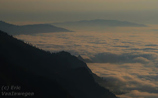 (Yup, once again I'm blaming the altitude, not my lack of excercise.) In the morning, I got the chance to drive above the clouds. Now, I've driven through them and hiked above them, but never driven above them. So cool.
Gotta get back on the road before I get to complacent in this coffee shop / brew pub / restaurant in Joseph, Or. (If I lived near by, I'd never leave!)

Anyway, now that that's out of the way... I've been to one amazing part of Hell's Canyon area. The drive out to Hat Point is both difficult and oh-so-worth-it. Combine the best and worst parts of that dirt road in UP Mi and the GttSR in GNP. 24 unpaved miles of switch-backs, no shoulders, and amazing scenery. But it gets you out to the Hat Point Look Out, which looks into Hells Canyon. (As close to the canyon as I'm going to get on this trip, alas.) Hells Canyon is actually deeper than the Grand Canyon. There's a fire-tower at the top of Hat Point, in case the mountain's not high enough for you. But, since the point is at 7000 feet high, bring oxygen, or plan on taking longer than you might otherwise...
 (Yup, once again I'm blaming the altitude, not my lack of excercise.) In the morning, I got the chance to drive above the clouds. Now, I've driven through them and hiked above them, but never driven above them. So cool.
Gotta get back on the road before I get to complacent in this coffee shop / brew pub / restaurant in Joseph, Or. (If I lived near by, I'd never leave!)
Tuesday, July 22, 2008
Three quick posts below
Now that I'm on the road again, I realized that I've been remiss in posting. I've been so busy having fun that I've forgotten to post about it here.
Yesterday was my western-most day of the trip. I spent a little bit of time along the Olympic coast.
 I have just hit the Oregon / Washington border. The drive through the Cascades was incredible. Once you hit the eastern side, the whole Topological-influence-on-the-ecosystems was amazingly obvious. On the western side, where all of the rain falls, the mountains are covered with thick, lush forests. About ten miles down the road from the pass in the mountains, the forests abruptly turn in to prairie hills. The change is so fast that it just really hits you.
Anyway, enjoy the (late) posts; time to get myself in gear to make Hell's Canyon tonight.
Yesterday was my western-most day of the trip. I spent a little bit of time along the Olympic coast.
 I have just hit the Oregon / Washington border. The drive through the Cascades was incredible. Once you hit the eastern side, the whole Topological-influence-on-the-ecosystems was amazingly obvious. On the western side, where all of the rain falls, the mountains are covered with thick, lush forests. About ten miles down the road from the pass in the mountains, the forests abruptly turn in to prairie hills. The change is so fast that it just really hits you.
 Anyway, enjoy the (late) posts; time to get myself in gear to make Hell's Canyon tonight.
Holy-Freakin'-Huge-Trees, Flying-Nocturnal-Echo-Locating-Mammal-Man!
I was almost going to skip Olympia National Park, and that would have been a crime. Looking at my schedule, I realized that I need to re-prioritize and spend an extra day in Washington exploring the Olympic Peninsula. Yet another place, that, you guessed it, deserves its own trip, and not just a quick run-through. Seattle is known for being a rainy-cloudy city, but it has nothing on the forests of the peninsula. Between rain and snow and etc, they get (on average) 140 inches of precipitation. (I forgot that snow gets "rescaled" when you calculate precipitation; it's something like a foot to an inch, or so.) The ridiculous amount of rain gives the trees in ONP a chance to grow incredibly large. They have a neat display in one of the ranger stations of trees grown in ONP compared to tress of the same species grown elsewhere. The difference is staggering! In the ONP, the trees can grown almost ten times as much in one year. It's hard to get the impact of the size of the trees across in pictures, you lose your sense of scale without a reference mark. So, since I had no one to better looking who'd volunteer, I had to model in my shots. Since I also had to work the camera, this meant that I would set up the tripod, set the camera to the timer, push the button, and run as fast as I could to get into position. Sounds easy, right?
This fella was well over two hundred feet tall / long.

This fella was well over two hundred feet tall / long.
Seattle
After our driving and hiking, we explored Seattle's famous market downtown. Like a lot of these "farmers markets", it's become kinda touristy more so than a true farmers market. But there were still plenty of stalls selling fresh fish and produce, as well as some amazing places to get local cuisine. (The next food files will be a happier one.)


After exploring, I used the time to get the car an oil change (it's been more than 4k since I left Mass) and a haircut (think Egon Spengler from Ghostbusters, only shaggier), while my buddy and his girlfriend played a softball game. Afterwards, we toured a bit more of Seattle and went to the Space Needle for dinner. TSP restaurant has a reputation with the locals as being a tourist trap. It kinda is, but it's better than most. Although it was certainly expensive, it was (mostly) worth it. The atmosphere was entertaining; however the spin was a bit jerky at times. Not so much that you'd knock over a glass, but just enough to make you notice it. Overall, I'd say that, if you have the money to spare, go for it; if you're on a tight budget, you could skip it without missing too much.


After exploring, I used the time to get the car an oil change (it's been more than 4k since I left Mass) and a haircut (think Egon Spengler from Ghostbusters, only shaggier), while my buddy and his girlfriend played a softball game. Afterwards, we toured a bit more of Seattle and went to the Space Needle for dinner. TSP restaurant has a reputation with the locals as being a tourist trap. It kinda is, but it's better than most. Although it was certainly expensive, it was (mostly) worth it. The atmosphere was entertaining; however the spin was a bit jerky at times. Not so much that you'd knock over a glass, but just enough to make you notice it. Overall, I'd say that, if you have the money to spare, go for it; if you're on a tight budget, you could skip it without missing too much.
The Lonely Mountain
After a long haul of a drive from GNP, the next day, my buddy, his girlfriend and her kid and I decided to go to Mt Rainier. We were only able to walk about a bit, no backpacking or anything. It's another amazing place, worthy of a trip in and of itself. I call it the "Lonely Mountain" because it doesn't really have many neighbors, just parts of itself. It's a volcanic mountain (active, sort of), so it just grew were the hot spot is. On even kinda clear days, you can see the white glacier-covered top "floating" in the air from Seattle.
The park is set up so that you could climb to the top in two days. I'm not sure I'd be able to do that, but you never know. (Maybe one day I'll start on the High-Points in each state, so I'll have to.) Of course I took a bunch of pics, so here's one. (It's from the ride back home.)
The park is set up so that you could climb to the top in two days. I'm not sure I'd be able to do that, but you never know. (Maybe one day I'll start on the High-Points in each state, so I'll have to.) Of course I took a bunch of pics, so here's one. (It's from the ride back home.)

Friday, July 18, 2008
Fast Ponderings on GNP
So, now that I am on the road again, I figure it's time for a wrap-up on GNP. (That's Glacier National Park; try to keep up with the acronyms.)
GNP was yet another park that was worthy of its own trip. If I had another month, I wouldn't have seen it all. If I could spend a full year at GNP, it'd be different every day. It' very much the kind of place I could fall in love with (and, indeed, have). There are a couple of things that I should point out to anyone thinking of visiting the park. #1, if you don't like mountain roads, try visiting the National Grassland between the TRNP units. The Going to the Sun Road connects the two sides. The East-to-West route is less worrisome. You tend to be on the inside of the road most all of the way. West-to-East is a bit ... more knuckle-whitening. I now have fingernail marks in my steering wheel.
In the more people-frequented areas, some of the wildlife gets disturbingly familiar with humans. Up near Logan's Pass, at both the Hidden Lake overlook and the viewing area just to the West of the pass, mountain goats get so comfortable around people that I could have petted them, if I choose to. Needless to say, I now have some "Nature" shots of mountain goat kids. It's almost cheating.
Avalanche Lake is another popular destination. The trail is right next to one of the larger camping areas and is very well maintained. That is, it's well maintained right up to the point where it claims to stop. They even have a sign proclaiming that this is the "end of the trail, don't go any further." So, of course, there is a trail, and I did go further. But not too much. The US government may claim to possess the GNP, but it's really the grizzlies' property. The area just beyond the "end of trail" sign was decidedly grizzly territory. Brush about 6 feet tall, cascading streams, fresh fish supplies, plenty of places to make dens, etc. So, of course, I had to venture a little bit in, right? Just long enough to snap a couple of pictures (but I didn't even stay long enough to set up my tripod). Let's think about all of the things that were wrong with this idea: Lone hiker, hours getting long, no bear-spray, etc, etc. I made sure that I was one noisy hiker, and only went about 2 minutes into the end of the valley. For the next visit, I'm bringing at least one hiking partner, and at least one can of spray, and I am definitely going to return and head a little further in. Also, I did no backpacking. The Ptarmigan Path has my name on it, I think.
Time to get back in the car and get moving, I think. Sorry, no pics. They're still on the camera.
GNP was yet another park that was worthy of its own trip. If I had another month, I wouldn't have seen it all. If I could spend a full year at GNP, it'd be different every day. It' very much the kind of place I could fall in love with (and, indeed, have). There are a couple of things that I should point out to anyone thinking of visiting the park. #1, if you don't like mountain roads, try visiting the National Grassland between the TRNP units. The Going to the Sun Road connects the two sides. The East-to-West route is less worrisome. You tend to be on the inside of the road most all of the way. West-to-East is a bit ... more knuckle-whitening. I now have fingernail marks in my steering wheel.
In the more people-frequented areas, some of the wildlife gets disturbingly familiar with humans. Up near Logan's Pass, at both the Hidden Lake overlook and the viewing area just to the West of the pass, mountain goats get so comfortable around people that I could have petted them, if I choose to. Needless to say, I now have some "Nature" shots of mountain goat kids. It's almost cheating.
Avalanche Lake is another popular destination. The trail is right next to one of the larger camping areas and is very well maintained. That is, it's well maintained right up to the point where it claims to stop. They even have a sign proclaiming that this is the "end of the trail, don't go any further." So, of course, there is a trail, and I did go further. But not too much. The US government may claim to possess the GNP, but it's really the grizzlies' property. The area just beyond the "end of trail" sign was decidedly grizzly territory. Brush about 6 feet tall, cascading streams, fresh fish supplies, plenty of places to make dens, etc. So, of course, I had to venture a little bit in, right? Just long enough to snap a couple of pictures (but I didn't even stay long enough to set up my tripod). Let's think about all of the things that were wrong with this idea: Lone hiker, hours getting long, no bear-spray, etc, etc. I made sure that I was one noisy hiker, and only went about 2 minutes into the end of the valley. For the next visit, I'm bringing at least one hiking partner, and at least one can of spray, and I am definitely going to return and head a little further in. Also, I did no backpacking. The Ptarmigan Path has my name on it, I think.
Time to get back in the car and get moving, I think. Sorry, no pics. They're still on the camera.
Subscribe to:
Posts (Atom)